Map Status : None - You need to be logged if you want to do the surface mapping. Human : 8 Biological : 1 | Type : Rocky body 
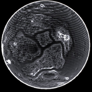
Radius : 2662.49 km - Area : 89.081 Mm² Temperature : 203 K Mass : 0.06 Earth Mass Gravity : 0.346 G Terraforming : None Composition : Rock (85.83%), Metal (14.17%), Ice (0%) Volcanism : No volcanism Atmosphere : Thin Sulphur dioxide Pressure : 0.002 atm | Materials : iron (19.71%) sulphur (17.41%) nickel (14.91%) carbon (14.64%) phosphorus (9.37%) chromium (8.87%) manganese (8.14%) selenium (2.73%) cadmium (1.53%) niobium (1.35%) tellurium (1.34%) |
POI : Surface Station Type : Settlement Name : Worster Agricultural Biome Coordinates : (-12.0127,-141.2634) 2D 3D First discovered for ExTool : Andy Arkwright |
Date | Planet | Near coordinate | Dist | 2D | 3D | Type | TXT1 |
---|---|---|---|---|---|---|---|
3308-06-08 22:03:56 | HIP 48095 A 7 a | (-12.0133,-141.2627) | 0 s | 2D | 3D | Stlmt | Worster Agricultural Biome - (-12.0127,-141.2634) - 3825321472 |
3308-06-08 22:01:15 | HIP 48095 A 7 a | (-12.012,-141.264) | 0 s | 2D | 3D | Surf | SurfaceStation - Worster Agricultural Biome - 3825321472 |
3308-06-08 22:00:14 | HIP 48095 A 7 a | (-12.6631,-141.6465) | 0 s | 2D | 3D | Stlmt | Worster Agricultural Biome - (-12.0127,-141.2634) - 3825321472 |
Original idea by SteFBlood & Sileo Developed by Sileo Planetary map by NASA WorldWind Celestial map by D3-Celestial Thx to Wing Atlantis, CMDR EfilOne, CMDR tonio-GMNH & CMDR Derek Windstorm |