My CMDR name :
My position :
My system :


System : Coelatuvean - EDSM
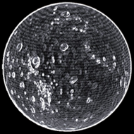
Planet : Coelatuvean B 7 a - EDSM


Map Status : None - You need to be logged if you want to do the surface mapping.

 Type : Icy body
Radius : 2099.3 km - Area : 55.381 Mm²
Temperature : 49 K
Mass : 0.013 Earth Mass
Gravity : 0.123 G
Terraforming : Not terraformable

Composition : Ice (87.78%), Rock (10.51%), Metal (1.71%)
Volcanism : No volcanism

Atmosphere : No atmosphere
Pressure : None
 Materials :
    sulphur (27.88%)
    carbon (23.45%)
    phosphorus (15.01%)
    iron (12.23%)
    nickel (9.25%)
    chromium (5.5%)
    zinc (3.32%)
    zirconium (1.42%)
    yttrium (0.73%)
    tungsten (0.67%)
    mercury (0.53%)


Last update with EDSM : 3308-10-21 19:45:07


POI : Surface Station
Type : Crater Outpost
Name : Prandtl Beacon
Coordinates : (-28.7671,-135.0209) 2D 3D
First discovered for ExTool : NWSpacek

DatePlanetNear coordinateDist2D3DTypeTXT1
3308-05-01 15:45:17Coelatuvean B 7 a(-28.7418,-135.0518)0 s2D3DSurfSurfaceStation - Prandtl Beacon - 3513187072
3308-05-01 15:44:26Coelatuvean B 7 a(-28.7628,-135.7998)0 s2D3DStlmtPrandtl Beacon - (-28.7671,-135.0209) - 3513187072
3308-02-03 20:03:28Coelatuvean B 7 a(-28.7887,-135.0098)0 s2D3DSurfSurfaceStation - Prandtl Beacon - 3513187072
3308-02-03 20:01:41Coelatuvean B 7 a(-28.5424,-134.2127)0 s2D3DStlmtPrandtl Beacon - (-28.7672,-135.0209) - 3513187072


Original idea by SteFBlood & Sileo
Developed by Sileo
Planetary map by NASA WorldWind
Celestial map by D3-Celestial
Thx to Wing Atlantis, CMDR EfilOne, CMDR tonio-GMNH & CMDR Derek Windstorm